Wisconsin’s fall color season rolls from the Northwoods south through October, giving you four to five weeks of strong color across landscapes as different as Lake Superior shoreline and Mississippi River bluffs. Here are the drives worth planning a trip around, with timing and practical details for each.
How Wisconsin Fall Color Works
Wisconsin’s fall season doesn’t peak all at once. The Northwoods around Minocqua, Eagle River, and Hayward turns first, with sugar maple, red maple, yellow birch, and quaking aspen going simultaneously across millions of acres of mixed forest. That window runs roughly September 25 through October 8 in an average year. The central and southern parts of the state follow over the next two weeks, with Door County’s bay-side bluffs peaking in the first two weeks of October and the Great River Road’s limestone ridges and the quartzite bluffs at Devil’s Lake near Baraboo typically peaking October 8 through 22. If you can only take one trip and want to catch multiple regions, aim for the first full weekend of October, which usually falls between the end of Northwoods peak and the start of Door County’s. The Best Time to Visit Wisconsin page gives the full seasonal overview if you are still deciding when to come.
Highway 42 Along the Door Peninsula Bay Shore
The 70-mile run on Wisconsin Highway 42 from Sturgeon Bay north to Ellison Bay is the better fall color drive of the two main Door Peninsula roads. The route threads through Fish Creek, Ephraim, and Sister Bay past cherry orchard rows, hardwood bluffs above Green Bay, and the overlooks along Peninsula State Park’s western edge. Color typically peaks in Door County from October 1 through October 15, with the bay-side bluffs hitting full color three to five days ahead of the Lake Michigan shore to the east. That timing difference is worth knowing if you have to pick one day on the road.
A practical move is to drive Highway 42 north in the morning, when the light hits the bluffs from the east, then loop back south on Highway 57 in the afternoon. The two roads run six to eight miles apart on opposite sides of the peninsula, so a full loop stays under 140 miles total with no backtracking. The Best Fall Color Drives in Wisconsin guide covers the complete Door County loop with specific stops along the way. Book lodging in Fish Creek, Ephraim, or Sister Bay four to six weeks ahead for any October weekend: the smaller bay-view inns fill as fast in fall as they do in July.
Wisconsin Highway 35 and the Great River Road Bluffs
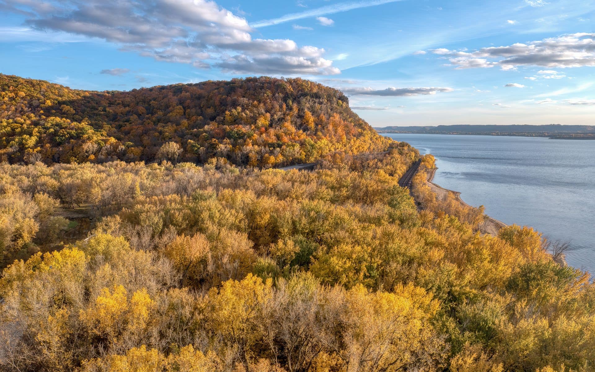
Highway 35 between La Crosse and Cassville runs about 120 miles down the Mississippi River bluffs, and it is the most dramatically vertical fall color drive in the state. The Great River Road follows the Mississippi the full length of Wisconsin, but the bluff-intensive stretch from La Crosse south through the Driftless Area is where the ridgeline overlooks change at every bend. Because glaciers never touched this corner of Wisconsin, the terrain is steep and angular in a way that the rest of the state is not. Color here peaks roughly October 8 through October 22 in an average year.
Start with Grandad Bluff in La Crosse. The overlook is reached by a one-mile drive up Grandad Bluff Road from Bliss Road on the east side of town, it is free, and the 600-foot elevation puts you above the river valley looking both north and south toward Iowa and Minnesota. From La Crosse, drive Highway 35 south through Genoa, Victory, and Ferryville. The stretch from Ferryville to Seneca is about 18 miles with no anchor town pulling in traffic, which means the ridgeline overlooks along that section rarely crowd up even on peak weekends. La Crosse is an underrated fall base: better room rates than Door County on color weekends and a city restaurant scene that makes dinner easy. If food is part of the plan, the Wisconsin cheese lovers guide covers several stops worth building into this corridor.
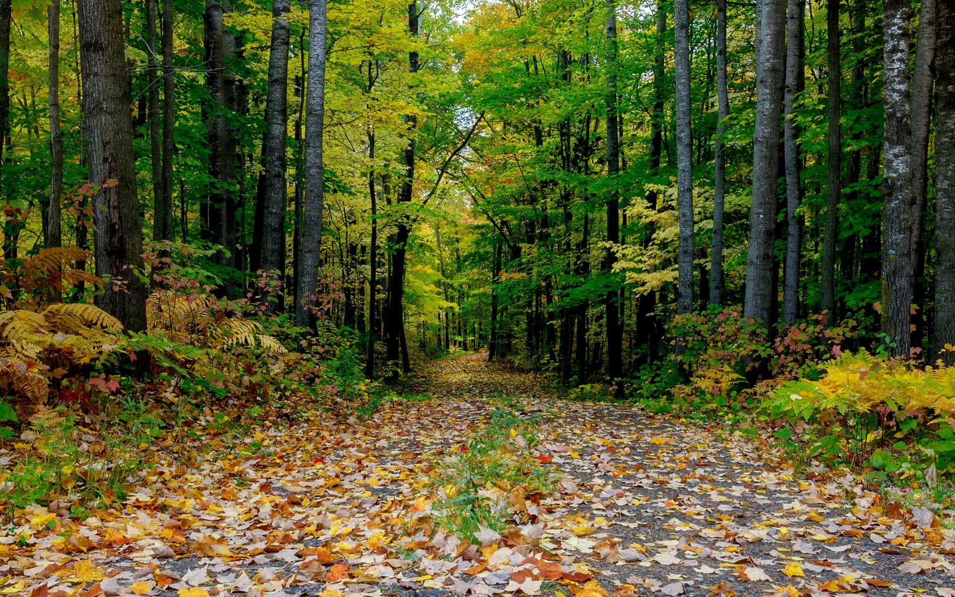
County Road C Loop in the Northwoods
County Road C from Rhinelander west toward Tomahawk runs through the Chequamegon-Nicolet National Forest for most of its length and is one of the most immersive Northwoods color drives without requiring a major detour. Rhinelander sits about 90 miles north of Wausau on US-51. From town, take County Road C west and follow it through roughly 40 miles of mature maple, birch, and aspen before picking up US-8 back east toward town. The full loop from Rhinelander is about 80 miles and takes two to two and a half hours with stops.
Northwoods color in this corridor peaks September 25 through October 8. One thing worth knowing before you head out: there are almost no services between Tomahawk and the Rhinelander area for a long stretch of County Road C. Fill the gas tank and bring water in Tomahawk before heading north. The payoff is national forest with minimal development, almost no cell signal, and zero strip commercial along the route. The Wisconsin DNR publishes a free fall color report online every week from late September through mid-October, tracking current progress by county. It is the most reliable tool for picking the right week in this corridor, where color can run a week early or late depending on how summer drought or a wet August played out.
Kettle Moraine Scenic Drive
The Kettle Moraine Scenic Drive is a 115-mile marked route through two units of Kettle Moraine State Forest between Sheboygan County and the Whitewater area south of Madison. It is the most accessible fall color drive from Milwaukee and Chicago because the Northern Unit entrance sits about 50 miles northwest of Milwaukee via US-45 and then west on Highway 67 near Dundee. The oak and maple mix on the drumlins and kettle topography of the Northern Unit delivers strong color, with the Southern Unit near Eagle and La Grange adding rolling open farmland between forest corridors for a different visual rhythm. Color in this corridor peaks October 5 through 20.
A vehicle admission sticker is required for state forest parking areas: an estimated $8 to $12 per day or about $28 to $35 for an annual pass that covers all Wisconsin state parks and forests statewide, which pays off if you plan to visit more than three parks on one trip. For an elevated view without a hard hike, the platform observation tower at Lapham Peak in the Southern Unit off County Road C near Delafield gives you a wide view across the kettle-and-kame terrain at no extra cost beyond the vehicle sticker. Most drivers miss it because there is no prominent sign from the Scenic Drive itself, so look for the Lapham Peak State Recreation Area turnoff directly.
Highway 13 Around the Bayfield Peninsula
Highway 13 from Ashland north to Bayfield and then around the peninsula to Cornucopia covers about 90 miles and pairs Lake Superior water views with strong Northwoods color. The hillside apple orchards above Bayfield go gold and copper around the same time the maples peak, and the Bayfield Apple Festival on the first full weekend of October pulls the whole picture together. Bayfield sits 70 miles west of Ashland via US-2 and then north on Highway 13. The town itself is small enough that you can walk to the ferry dock, the waterfront shops, and the orchard overlook trails on foot once you park.
The stretch of Highway 13 from Cornucopia north toward the tip of the peninsula is the part most visitors skip because there is no obvious draw beyond the drive itself. The road narrows, the orchards thin out, and you are on the Lake Superior shoreline with the Apostle Islands visible offshore. Color here peaks late September through early October, a few days ahead of Door County and a week ahead of the Driftless ridges. Book lodging in Bayfield four to six weeks ahead for the Apple Festival weekend. The town has a limited room count and fills completely for that first October weekend every year. Madeline Island, reached by a 20-minute ferry from the Bayfield dock, is also worth a half-day if you want to extend the drive to include an island loop on the inner roads.
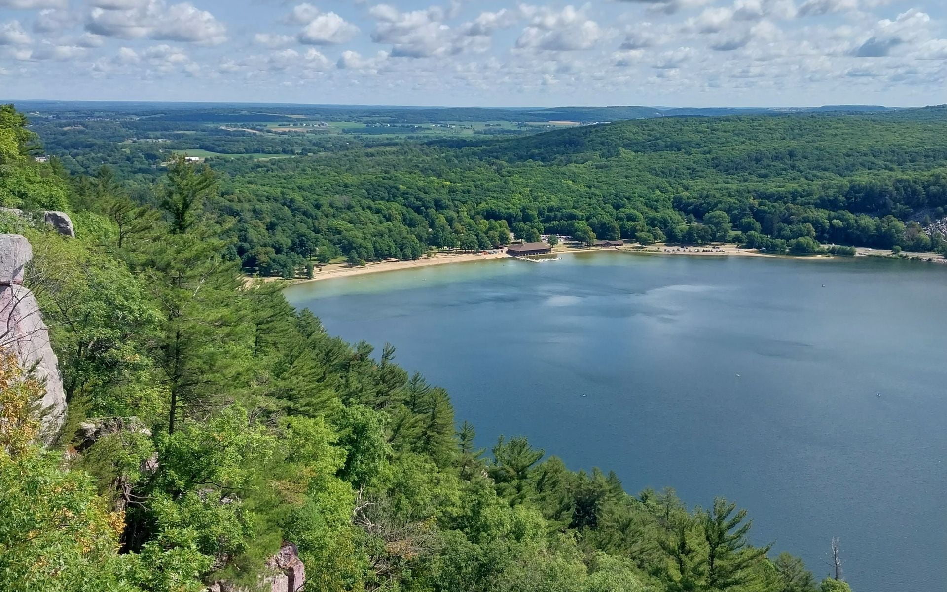
Baraboo Hills and the Devil’s Lake Corridor
For travelers based in Madison, the Baraboo Hills drive is the closest strong fall color option. Highway 123 north from Baraboo to Reedsburg and back via County Highway W threads through the wooded ridges of the Baraboo Range, with Devil’s Lake State Park as the anchor stop. The park sits about 45 minutes from Madison and 15 minutes from Wisconsin Dells off US-12. The 500-foot quartzite bluffs above the lake frame color against exposed rock faces in a way that flat lake parks cannot match. The East Bluff Trail puts you above the water looking down through the canopy, and it is one of the better elevated fall color views in the southern part of the state.
A vehicle admission sticker is required to enter Devil’s Lake by car: an estimated $8 to $12 per day. Parking lots at the south shore fill on October weekends, so plan to arrive before 9 a.m. or after 4 p.m. The roads through the Baraboo Hills outside the park, including County Highway DL and the back routes through the Baraboo Range quartzite ridges, are open without a fee and deliver similar scenery at a slower pace. The Wisconsin Travel Guide covers lodging in Baraboo and the Dells area if you want to turn this into an overnight trip.
How to Time and Plan Your Fall Color Drive
The Wisconsin DNR fall color report is the single most reliable tool for timing any of these drives. It publishes weekly updates by county from late September through mid-October and tracks current color stage from early change through peak and past-peak. Bookmark it before your trip. Beyond the report, watch the extended forecast for the Northwoods: a hard frost accelerates color change significantly in the maple-heavy north, which can compress a two-week window into five or six days.
For logistics across all five of these routes, a few things hold true regardless of where you go. Leaf-peeper weekends in Door County and Bayfield book out as fast as summer peak, so October weekends in either place need reservations four to eight weeks out. The Great River Road and Kettle Moraine drives have better availability because they lack the lodging premium of the peninsula destinations. If fall color is the main draw but budget matters, the La Crosse base for the Great River Road gives you city hotel rates on the same weekends when Door County charges resort prices. The Northwoods drives out of Rhinelander also hold good availability on fall weekends at mid-range chain properties in town, even when the lakeside resorts have filled up.
Frequently asked questions
When is the best time to drive fall color in Wisconsin?
It depends on which part of the state you are driving. The Northwoods around Minocqua, Rhinelander, and Hayward peaks September 25 through October 8. The Bayfield Peninsula and Lake Superior shore peak around the same time, with the Bayfield Apple Festival on the first full weekend of October landing right in the middle. Door County peaks October 1 through 15. Central Wisconsin including Devil’s Lake and Kettle Moraine peaks October 5 through 20. The Driftless Area and Great River Road bluffs peak October 8 through 22. Any year can shift up to two weeks early or late, so check the Wisconsin DNR’s free weekly fall color report before you finalize dates.
Which Wisconsin fall color drive is the easiest from Milwaukee or Chicago?
The Kettle Moraine Scenic Drive is the most accessible from both cities. The Northern Unit entrance near Dundee is about 50 miles northwest of Milwaukee, and the full 115-mile marked route runs south toward Whitewater without requiring any interstate driving. From Chicago, it adds about 90 minutes to a Milwaukee approach on I-94. Door County is about two and a half hours from Milwaukee and four hours from Chicago, which makes it a longer day trip but a manageable weekend drive. The Great River Road near La Crosse runs about three hours from Madison and about four hours from Milwaukee.
Do I need a state park pass for Wisconsin fall color drives?
You need a vehicle admission sticker for state park and state forest parking areas, including Devil’s Lake State Park and the Kettle Moraine parking lots. A daily pass runs an estimated $8 to $12 per vehicle, and an annual pass covering all Wisconsin state parks and forests runs an estimated $28 to $35. Most county roads, state forest roads, and Great River Road overlooks are free without any pass. Peninsula State Park in Door County requires the vehicle sticker by car but is open to cyclists and walkers without one.
Can I combine a fall color drive with a supper club dinner?
This is exactly how Wisconsinites do it. The Great River Road corridor, the Door County routes, and the Baraboo Hills all have supper clubs within easy reach of the drives. A Friday fish fry at a supper club is the natural bookend to a fall afternoon on the road. The Best Fall Color Drives in Wisconsin guide pairs specific supper club stops with each route, and the Best Time to Visit Wisconsin page gives broader seasonal context for planning around both color and local events.