Wisconsin has 66 state parks and forests, and a handful of them stand out for the quality of their terrain, the drama of their scenery, or the plain fact that they’re worth rearranging a trip to reach.
What Makes a Wisconsin State Park Worth the Drive
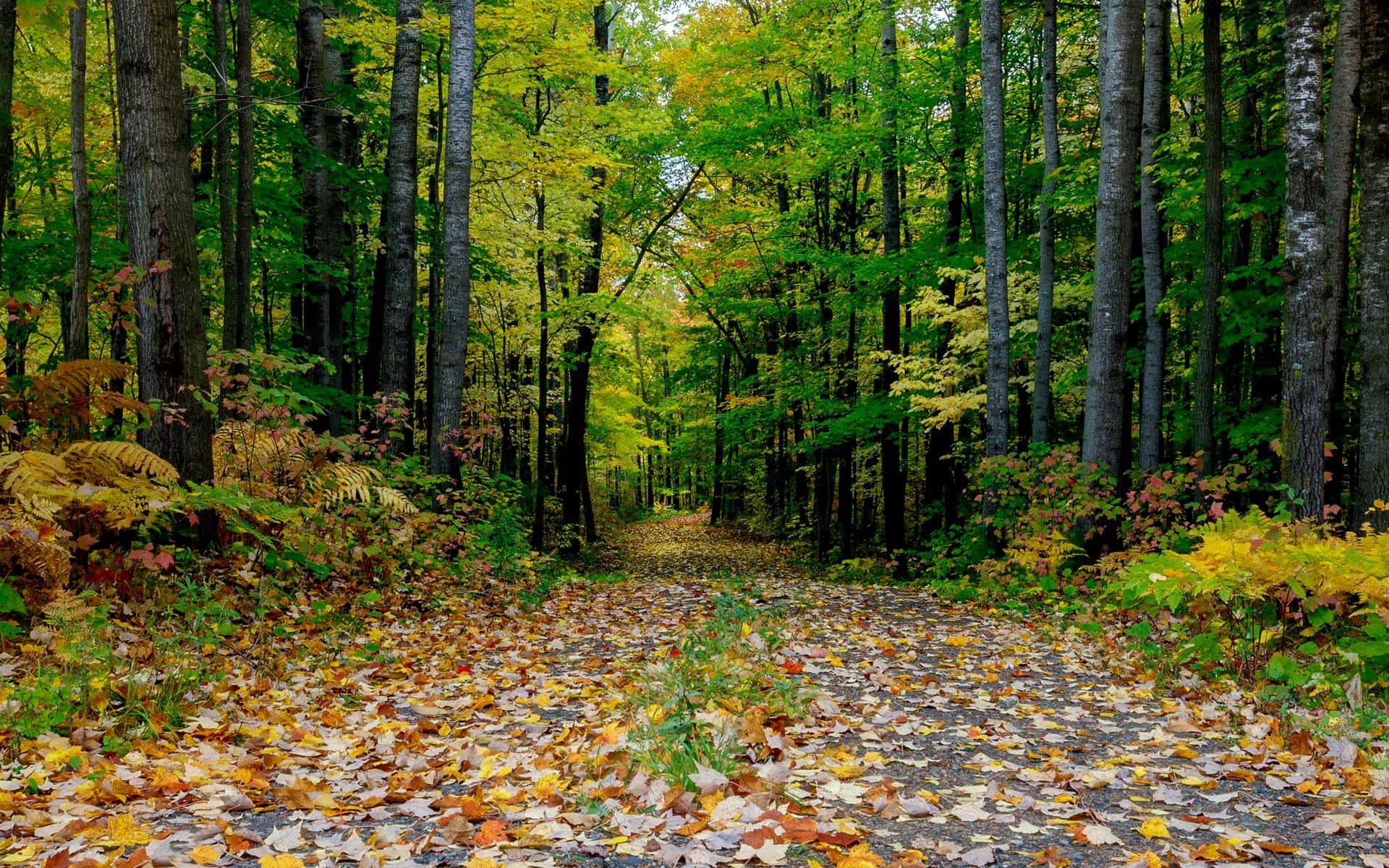
Wisconsin’s state parks vary enormously. Some are narrow strips of trail through county forest. Others anchor entire weekend trips. The six parks below earned their place by offering something specific: dramatic terrain, a geological feature you won’t find most places, a legitimate hiking challenge, or water access that justifies the drive on its own. We also spread them across the state so you’re not reading about six variations on the same Baraboo Hills bluff.
Every Wisconsin state park charges a vehicle admission fee at the gate. Daily passes run roughly $8 for Wisconsin residents and $11 for out-of-state plates. Annual passes are about $28 (resident) and $38 (non-resident), sold at any park entrance or through the Wisconsin DNR website. If you’re hitting two or more parks on a single trip, the annual pass almost always pays for itself. Note that it’s priced per vehicle, not per person. Before you plan the timing, our Best Time to Visit Wisconsin guide covers what each season looks like across the state, including what parks fill to capacity and when.
For the full ranked rundown with ratings and visitor info, check out the Best State Parks in Wisconsin guide. What follows is a deeper look at the six that belong on your short list.
Devil’s Lake State Park
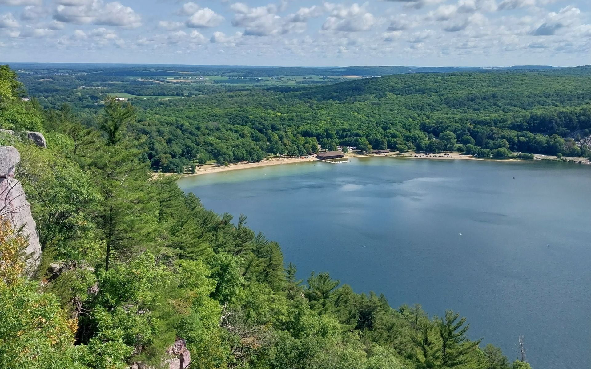
Devil’s Lake is Wisconsin’s most-visited state park, and it earns that label honestly. The park sits near Baraboo in Sauk County, about 15 minutes south of Wisconsin Dells off US-12, and it puts a spring-fed lake at the base of 500-foot quartzite bluffs. Those bluffs are some of the oldest rock in the state, far predating the glaciers that shaped the terrain around them. The lake itself is a closed basin with no stream inlet or outlet, fed entirely by underground springs, which is why the water clarity holds up even in summer.
The East Bluff Trail and the Balanced Rock Trail are the main routes to the top, and neither is casual. Both involve sustained climbing over quartzite boulders, with CCC-built stonework from the 1930s marking the steepest passages. The panorama from the bluff edge looks directly down into the lake bowl below and out across the Baraboo Hills. Devil’s Lake is also a key segment of the Ice Age Trail, the 1,200-mile footpath that traces Wisconsin’s glacial boundary from Potawatomi State Park in Door County to Interstate State Park on the Minnesota border.
On a July or August weekend, the parking lots fill by 9 a.m. Arrive early or expect to wait. Rock climbers work the south-shore bluff faces year-round, and the park allows climbing. Two swimming beaches bookend the lake on the north and south shores. Baraboo is four miles north if you need food or a place to stay, and Circus World Museum is right there in town for a rainy-day option.
Peninsula State Park
If you’re going to Door County, Peninsula State Park deserves a full day. It covers 3,776 acres on the Green Bay side of the Door Peninsula, between Fish Creek and Ephraim, with more than eight miles of shoreline and a trail and bike-path network that could fill a weekend on its own. The park doesn’t feel as crowded as the rest of Door County in July, which is partly because it’s so large and partly because many visitors only dip in for an hour.
Eagle Bluff Lighthouse, built in 1868, sits on a rock point above the bay and opens for tours during summer. The park’s observation tower gives a wide view north across Green Bay toward the Garden Peninsula in Michigan on clear days. Nicolet Beach, the main swimming area, faces Green Bay rather than open Lake Michigan, which means calmer water and temperatures that warm up by July. The park has a nine-hole golf course, horseback-riding rentals, and about 20 miles of trails ranging from flat shoreline paths to ridge routes with real elevation.
Peninsula is the natural anchor for any Door County itinerary. If you’re figuring out how to spend your time on the peninsula, the how many days in Door County guide helps you stack the park with the other villages and stops across the peninsula.
Interstate State Park
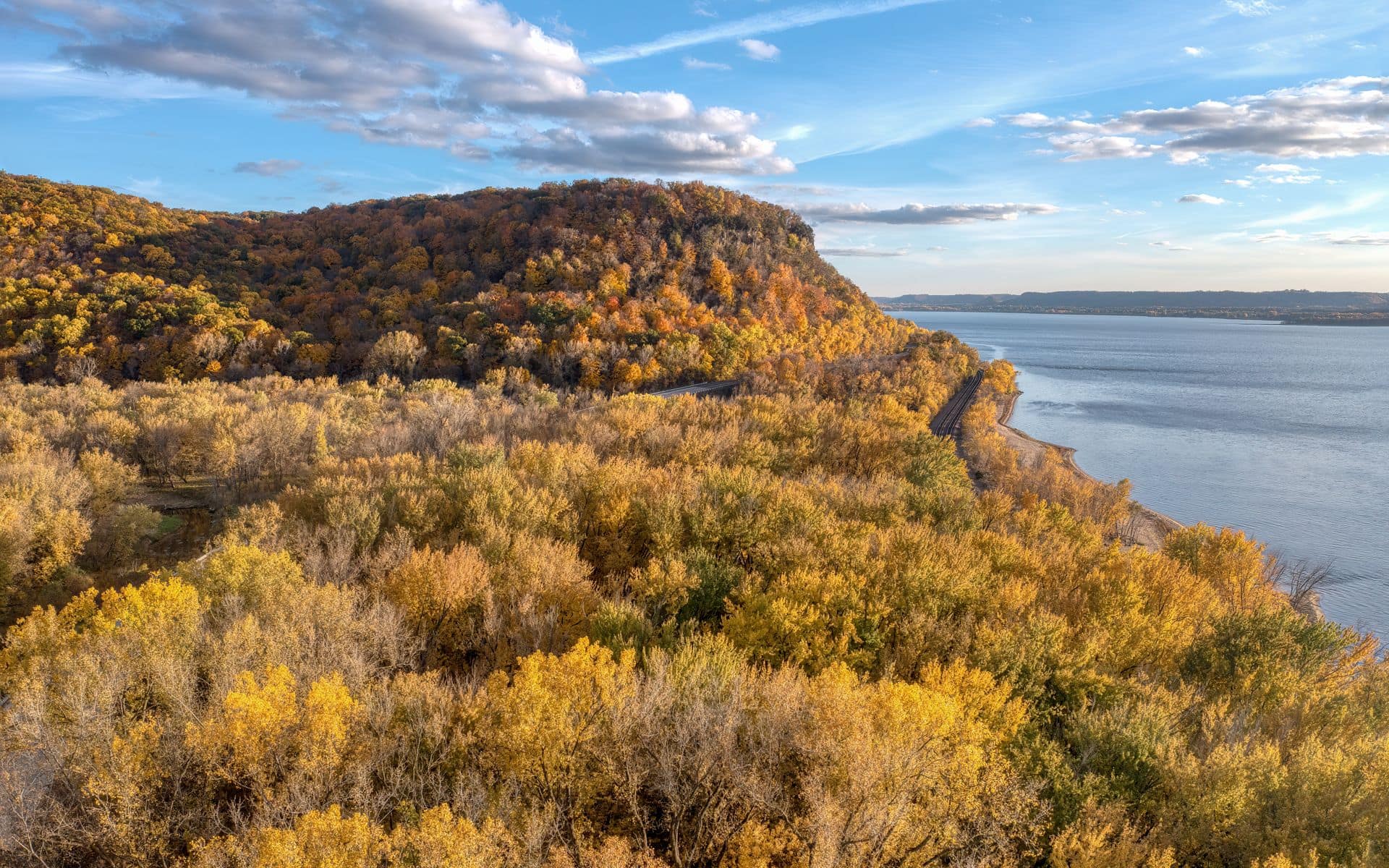
Interstate State Park is at St. Croix Falls in Polk County, on the Wisconsin bank of the St. Croix River. Minnesota has its own matching park directly across the water, hence the name. The St. Croix River here runs through a basalt canyon carved by some of the largest floods in North American prehistory, when glacial meltwater forced its way south through a channel in ancient volcanic rock. The Ice Age Interpretive Center inside the park explains the story clearly, and it’s worth 30 minutes before you hit the trail.
The geological centerpiece is the glacial potholes. As meltwater rushed through the canyon, it trapped gravel and boulders in depressions in the rock and spun them in circles for centuries, drilling perfectly cylindrical holes into the basalt. Some are 10 feet across and 15 feet deep. The Caldron Falls pothole reaches approximately 60 feet, making it one of the deepest documented glacial potholes in the world. You can walk within a few feet of the openings and look straight down. Kayakers and canoeists put in at the park for floats on the St. Croix. The park is about 90 miles east of Minneapolis-St. Paul (MSP), which makes it the most accessible Wisconsin state park from the Twin Cities.
Copper Falls State Park
Copper Falls is in Mellen, a small town in Ashland County, about 4.5 hours north of Madison and 45 minutes south of Bayfield on WI-13. The park is under 3,000 acres and the drive is long, but the Bad River gorge at its center makes it worth the trip for anyone who values waterfall quality over convenience. The main cascade, Copper Falls, drops about 29 feet into a sandstone-and-basalt gorge. Brownstone Falls is a short walk downstream, another 30-foot drop where the Tyler Forks River meets the Bad River.
The copper-colored staining in the gorge walls comes from iron and copper minerals in the Precambrian bedrock, not from any copper-mining operation in the area. The main loop trail is about 1.7 miles and covers both falls with a suspension bridge over the gorge and multiple viewpoints into the canyon. Old-growth hemlock and white pine shade the trail even in late July, which is unusual for Wisconsin parks where most old forest was logged out by 1920. A small swimming beach sits on Tyler Forks above the gorge, and the park has a campground. If you’re driving up to the Apostle Islands, combine these two stops: Mellen is 45 minutes south of Bayfield, and the drive up WI-13 from Mellen is a good introduction to the Lake Superior shoreline.
Governor Dodge State Park
Governor Dodge is in Dodgeville, Iowa County, about 40 miles west of Madison off US-18/151 and 15 miles from Spring Green. At roughly 5,047 acres, it’s one of the largest state parks in Wisconsin, and it’s the right choice when you want a full weekend of varied activity rather than one signature feature. Two impoundment lakes, Cox Hollow Lake and Twin Valley Lake, have swimming beaches, fishing docks, and canoe and kayak rentals. Nearly 27 miles of trails cross oak-and-hickory ridges, sandstone outcroppings, and spring-fed hollows.
The Stephens Falls trail, about two miles round trip, leads to a 25-foot waterfall tucked into a sandstone hollow that most visitors miss. Horseback riding is allowed on designated trails, and the equestrian campground here is one of the better-developed horse camps in the state park system. The surrounding Driftless Area escaped the glaciers entirely, which means the topography is sharper and more varied than you’d find in central or northern Wisconsin: ridges instead of drumlins, stream-cut valleys instead of glacial lakes. The House on the Rock is 15 miles north on WI-23, and Frank Lloyd Wright’s Taliesin is in Spring Green, another 15 miles northeast, so a Governor Dodge trip fits naturally into a broader southwest Wisconsin weekend.
For reference, the Lake Geneva resort area is another southern Wisconsin destination worth knowing about before you plan a trip to this part of the state. The Lake Geneva weekend guide covers a very different kind of Wisconsin day trip, about 90 miles east of Dodgeville, if you want to combine an outdoors stop with some resort-town time.
Kohler-Andrae State Park
Kohler-Andrae is on the Lake Michigan shore in Sheboygan County, about 8 miles south of Sheboygan and an hour north of Milwaukee via I-43. Most Wisconsin state parks sit on lakes or rivers in the interior, which makes the Lake Michigan coastline here genuinely different. The park has 2.5 miles of sandy beach backed by sand dunes that reach up to 50 feet high, plus a dune cordwalk that routes you through the dune system on a raised boardwalk without trampling the vegetation.
The Sanderling Nature Center at the park entrance covers the Lake Michigan coastal ecosystem and is a good stop before you walk the beach, especially with children. The beach faces east into open Lake Michigan, so wave action is real and water temperatures stay in the low to mid 50s°F through June, warming to the low 60s in July and August. Check the swim-risk flag at the beach entrance before you go in. Lake Michigan’s rip currents and cold-shock risk are documented, and the flags are posted for a reason. Outside of swimming season, the dune walk, the shoreline trail, and the Cordova Marsh observation area are still worth the vehicle fee. The park combines naturally with a Milwaukee trip: the Wisconsin Travel Guide home page has more on mixing city stops with outdoor time in the southeast region of the state.
Frequently asked questions
Do you need a sticker or pass to enter Wisconsin state parks?
Yes. Every Wisconsin state park charges a vehicle admission fee, collected at the gate or through an automated kiosk. Daily passes run roughly $8 for Wisconsin residents and $11 for out-of-state plates (these rates are approximate; verify with the Wisconsin DNR before you go). Annual passes are about $28 (resident) and $38 (non-resident), sold at park entrances or online. If you’re visiting more than two parks on a single trip, the annual pass pays off immediately. The sticker is per vehicle, not per person, so a carload pays the same as a solo driver. Some parks, including Devil’s Lake and Peninsula in Door County, also require campsite reservations months in advance for summer weekends.
What is the best Wisconsin state park for families with young kids?
Peninsula State Park in Door County is the most versatile choice for families: flat bike trails (rentals are available inside the park), a calm swimming beach at Nicolet Beach on Green Bay rather than the rougher open-lake side, and lighthouse tours in summer. Devil’s Lake is popular but the most rewarding trails involve boulder scrambling on steep quartzite bluffs, which younger children may find difficult. Kohler-Andrae near Sheboygan is a good alternative for families who want a beach day: the dune cordwalk is flat and the nature center gives kids context for what they’re looking at. The Best State Parks in Wisconsin guide includes family-difficulty notes for each park.
When is the best time of year to visit Wisconsin state parks?
Late May through mid-June is the sweet spot for avoiding summer crowds while still getting reliable weather and full green canopy. Wildflowers are still out, the trails are soft, and you won’t wait for a parking spot at Devil’s Lake. July and August are peak season and the most crowded, especially at Devil’s Lake and Peninsula State Park. Fall color runs from late September into mid-October in the north (Copper Falls, Interstate) and a week or two later in the south (Governor Dodge, Kohler-Andrae). Winter closes some facilities but the parks stay open, and trails at Devil’s Lake and Interstate are walkable on snowshoes. See our Best Time to Visit Wisconsin page for a full seasonal breakdown.