How We Picked These Drives
These seven routes were chosen for payoff per mile. Each one moves through a landscape that is specific to Wisconsin and changes noticeably as you go. We weighted variety of terrain, road quality across seasons, pull-off opportunities, and the presence of towns worth getting out of the car for. A route earns its place here by earning your time. Use the Wisconsin Travel Guide to plan your overall trip, and browse Hotels and Resorts near each route before you book, since many of the best lodging options fill on summer weekends and fall-color weekends weeks in advance.
The drives below span the whole state: the southwest river country, the glaciated ridge-and-kettle landscape of the southeast, the Door Peninsula jutting into Lake Michigan, the Lake Superior shore in the far north, and the chain-of-lakes country in the Northwoods. None of them require special vehicles or skills. All of them are better in person than any photograph suggests.
Great River Road: WI-35 from Prescott to Prairie du Chien
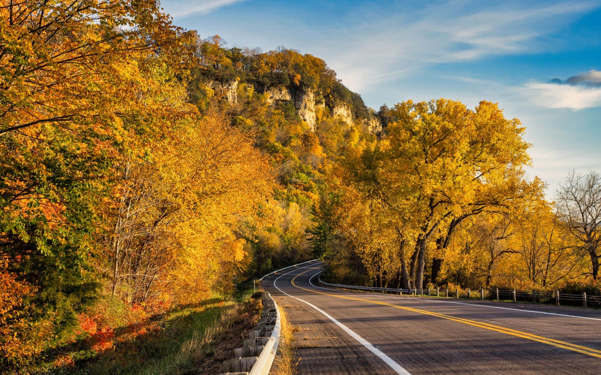
Wisconsin's portion of the Great River Road runs roughly 250 miles along State Highway 35, tracing the Mississippi River from Prescott in the north to the Iowa border near Prairie du Chien. The road hugs the base of the bluffs for long stretches, swinging through river towns like Pepin, Alma, and Trempealeau before passing through La Crosse and continuing south. Two state parks anchor the southern end: Perrot State Park near Trempealeau rises 500 feet above the river floodplain, and Wyalusing State Park near Prairie du Chien sits at the confluence of the Wisconsin and Mississippi rivers with overlooks that reach across three states on a clear day.
La Crosse is the natural midpoint stop, with a riverfront worth stretching your legs on and solid options for a meal. Buzzard Billy's on Pearl Street serves Cajun-inflected comfort food in a building with actual river character, and the Grandad Bluff overlook above town gives you a free, 600-foot view of the river valley and the Iowa bluffs beyond. Fall color peaks here from late September through mid-October, and this is one of the best fall drives in the Midwest: the bluffs go gold and orange while the river reflects the sky below. For more on the region, see Door County & the Bay if you are combining routes on a longer trip.
Door County Loop: WI-42 and WI-57
The Door Peninsula has about 300 miles of shoreline and only two main roads running its length: WI-42 on the Lake Michigan (east) side and WI-57 on the Green Bay (west) side. Drive them as a loop, north from Sturgeon Bay, and you will cover lighthouses, limestone cliffs, cherry orchards, and fishing harbors in under 90 miles. The east-side highway 42 is the more dramatic of the two: it passes Whitefish Dunes State Park and the shoreline at Cave Point County Park, where the lake waves cut arches and potholes into the dolomite shelf. Northport, at the tip, is the ferry dock for Washington Island, a 30-minute ride that adds another dimension to the day.
The west side along WI-57 runs through Egg Harbor and Fish Creek, both worth a stop for food or gallery browsing, before connecting back south through Baileys Harbor and the wooded interior. The whole loop takes three to four hours of driving without stops, but a full day with stops is more realistic if you want to walk any of the five state parks along the way. Cherry blossoms run mid-May, the harvest follows in mid-to-late July, and fall color fills the orchards with a second color wave in October. If you want to extend the region, a full Door County & the Bay overview covers all the side options.
Kettle Moraine Scenic Drive: Elkhart Lake to Slinger
The Kettle Moraine Scenic Drive is a 115-mile designated route that threads through both the Northern and Southern units of the Kettle Moraine State Forest in southeastern Wisconsin. The landscape is pure glacial: kames, kettles, moraines, and eskers give the road a rolling, almost lumpy quality that does not exist anywhere else in the state. The Northern Unit runs between Campbellsport and the village of Elkhart Lake, passing the Parnell Tower on a high wooded ridge where a short climb gives a wide view of the drumlin fields below. The forest segment is quieter than the Door County circuit and better for a weekday drive when you want empty roads.
The southern end of the route passes through the farm and orchard country around Eagle and Palmyra, and it is within an easy 45-minute drive of Milwaukee or an hour of Madison. The Fox & Hounds Restaurant & Tavern in Hubertus sits near the Kettle Moraine Northern Unit, a classic Wisconsin supper club in a 19th-century building with seven wood-burning fireplaces that make it a natural endpoint for a fall or winter drive. The Best Lakes in Wisconsin page covers several glacial lakes along this corridor, including Long Lake and Silver Lake, which are small, spring-fed, and worth a stop if you have time.
Highway 13: Bayfield Peninsula and Lake Superior Shore
WI-13 north from Ashland to Bayfield is only about 25 miles, but it earns its place on this list by delivering Lake Superior views that arrive suddenly and then stay with you. The road climbs onto the Bayfield Peninsula through apple and strawberry orchards and then drops toward the harbor with the Apostle Islands sitting offshore in the blue distance. On a clear afternoon in early October, when the orchard leaves are turning and the lake is still calm, there is no better single stretch of two-lane road in the state. From Bayfield, the loop west along WI-13 through Cornucopia adds another 35 miles of Lake Superior shoreline with sea stacks and sandstone formations visible from the roadside.
Bayfield itself has a population of just over 500 and a downtown that sits on the slope above the harbor. The Bayfield Apple Festival runs the first full weekend of October every year and turns the town into a genuine traffic challenge, so either arrive Thursday or plan a weekday visit if you want a quieter drive. Gas up in Ashland or Washburn before heading north, since station options thin out along the peninsula. The round-trip from Ashland through Bayfield and back is about 80 miles. Pair it with a visit to the lake if you want to see the best lakes Wisconsin has near the Superior shore.
Driftless Highlands: Spring Green to La Crosse on US-14 and WI-60
The Driftless Area in southwest Wisconsin was never scraped flat by glaciers, so what you get instead is a terrain of steep ridges, spring-fed creek valleys, and bluff roads that switchback between hollows and hilltops. The route worth driving connects Spring Green west on US-14 through Lone Rock and Richland Center, then picks up WI-60 to follow the Wisconsin River through the sandstone cliffs of the Lower Wisconsin State Riverway before reaching Prairie du Chien. From there, WI-35 can carry you north to La Crosse. The whole run from Spring Green to La Crosse is about 120 miles and takes two and a half to three hours with stops.
Spring Green itself warrants time. Taliesin, Frank Lloyd Wright's home and studio complex, sits on a south-facing ridge above the Wisconsin River a few miles south of town on County Road C, and self-guided walking tours run from May through October for around $15 to $25 per person (estimate, check current rates with the Taliesin Preservation site). Ishnala Supper Club on Mirror Lake Road in Lake Delton is a worthwhile dinner stop on the eastern approach to this corridor, an old-growth oak setting right on Mirror Lake with a reputation for prime steak and a proper old fashioned. Pick up local cheese on the way and check the Best Cheese Shops and Creameries in Wisconsin guide for producers in the Richland Center and Cashton areas.
Northwoods Lakes Loop: Minocqua and the Eagle River Chain
The Northwoods drives are less about dramatic terrain than about the accumulated effect of pine and hardwood forest, glassy lakes, and a pace that most of Wisconsin does not hit. WI-51 north from Wausau to Minocqua covers about 75 miles and transitions noticeably: dairy country gives way to dense forest around Tomahawk, and by the time you reach Minocqua the road is running between lakes on both sides. From Minocqua, County Road N and WI-70 east through Eagle River lets you follow the Turtle-Flambeau Flowage and the Rhinelander area lakes, covering one of the densest concentrations of freshwater lakes in the world. Eagle River alone sits at the entry point for a connected chain of 28 lakes.
The best color on this drive comes in early October, typically the first two weeks, when the hardwoods in the Northwoods transition earlier than the bluff country in the south. For an October weekend, plan on lodging booked out a month or more ahead. The Minocqua area has family-owned resorts along WI-51 and on Minocqua Lake itself that run from around $150 to $400 per night in peak fall (estimate range, verify with individual properties). If you are driving up from Chicago or Milwaukee, the run from Milwaukee Mitchell International (MKE) to Minocqua is about three hours and fifteen minutes on US-45 north.
Quick Comparison
Use this table to match a drive to your schedule and starting point.
| Drive | Distance | Best Season | Nearest Airport | Nearest Town |
|---|---|---|---|---|
| Great River Road (WI-35) | ~250 miles full route | Late Sept to mid-Oct (color); June to Aug | LSE (La Crosse) | La Crosse |
| Door County Loop (WI-42/57) | ~90 miles | May (cherry blossom); July to Oct | GRB (Green Bay) | Sturgeon Bay |
| Kettle Moraine Scenic Drive | 115 miles | Late Sept to mid-Oct; June to Aug | MKE (Milwaukee) | Elkhart Lake, Slinger |
| Highway 13: Bayfield Peninsula | ~80 miles round trip | Early Oct (apple harvest); July to Aug | CWA (Wausau) or MSP drive-in | Bayfield, Ashland |
| Driftless Highlands (US-14/WI-60) | ~120 miles | Late Sept to mid-Oct; May to June | MSN (Madison) | Spring Green, La Crosse |
| Northwoods Lakes Loop (WI-51/70) | ~100 miles loop | Early Oct; late June to Aug | MKE or CWA | Minocqua, Eagle River |
Frequently asked questions
When is the best time of year for a scenic drive in Wisconsin?
Late September through mid-October is the prime window for fall color on most of these routes. The Northwoods around Minocqua and Eagle River typically peak first, usually the first two weeks of October. The bluffs along the Great River Road and the Driftless Area follow in the second and third weeks of October. Summer from June through August gives you the most daylight hours and the best chance of lake views without haze. Spring drives in May are rewarding on the Door Peninsula, when the cherry orchards bloom around Fish Creek and Ephraim.
How long does it take to drive Wisconsin's Great River Road?
The Wisconsin segment of the Great River Road runs about 250 miles from Prescott south to the Iowa border near Prairie du Chien. Driving it straight through without stops takes roughly four to five hours on a good day. Most people break it into sections: La Crosse to Alma is a strong half-day drive with several worthwhile overlooks and river town stops. A full-length drive from Prescott to Prairie du Chien is a solid two-day trip if you want time to get out of the car at Perrot State Park, Wyalusing State Park, and a few of the smaller river towns along the way.
Are these scenic drives accessible in winter?
Most of them are, with some caveats. WI-35 along the Great River Road and the Kettle Moraine Scenic Drive stay plowed and passable through winter, though snow and ice are real from December through March and require appropriate tires. The Highway 13 Bayfield Peninsula drive is beautiful in snow but can be hazardous during lake-effect snowstorms coming off Lake Superior. The Northwoods drives to Minocqua and Eagle River are popular in winter for snowmobilers and are generally well-maintained. Plan for shorter daylight hours and check road conditions at 511 Wisconsin before heading north.
Which drive is best for combining with a food or cheese stop?
The Driftless Highlands route from Spring Green toward La Crosse is the best setup for a cheese and food detour. Southwestern Wisconsin has several farmstead creameries, and the Best Cheese Shops and Creameries in Wisconsin page covers the best producers in that part of the state. The Kettle Moraine Scenic Drive is also well-positioned for supper club stops, with The Fox & Hounds Restaurant & Tavern in Hubertus sitting right near the northern unit and the Grand Geneva Resort & Spa in Lake Geneva near the southern end of the route.